

Ruacana is situated at the western extremity of the Omusati region, where the plains give way to the rugged mountain landscape of Kaokoland. It is also the meeting point of different cultures – Otjiherero-speaking groups such as the Ovahimba, Ovazemba and Ovaherero, as well as the westernmost and smallest of the eight Aawambo communities, the Eunda and Onkolonkadhi.
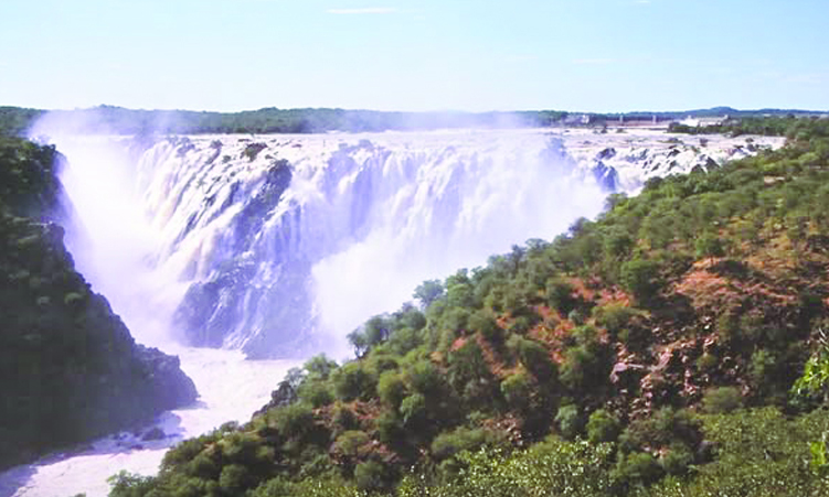
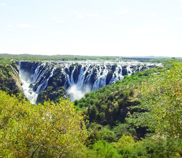
Ruacana is an Otjiherero name derived from the words orua hakahana, which means the ‘hurrying of the water’ – an apt name for the falls. The Kunene River splits into a network of channels and rocky islands just above the falls and then plummets into a 123-metre-deep gorge over a 700-metre-wide V-shaped rock shelf. When the river is in full flood, usually in March and April, the floodwater spills over the crest of the falls in a spectacular, almost solid curtain of water. The main flow is along the western and eastern gorges, but as the water level drops, the falls are reduced to numerous small falls and cascades spread along the face of the main fall.
Below the falls, the river turns westwards and zigzags along a gorge with near-vertical cliffs to Hippo Pools and the middle of the river forms the boundary between Angola and Namibia on the final 350km of its journey to the Atlantic Ocean.
The waterfall dispute
Where rivers are used to demarcate the borders between countries, the boundary is usually the middle of the river. Few visitors to Ruacana are, however, aware that as a result of a dispute between the German and Portuguese governments about the exact point from where the parallel of latitude should be drawn from the Kunene River to the Okavango River, the falls are entirely in Angolan territory.
The dispute remained unresolved during the German administration and was only resolved when the Boundary Convention met in Cape Town, South Africa in 1926. In terms of the agreement, the boundary would follow “… the middle line of the Kunene River, that is to say, the line drawn equidistant from both banks, from the mouth of the said river up to a point at the Ruacana Falls, above the crest or lip where the said middle line crosses the parallel of latitude, passing through the beacon placed on the left bank of the said river in July 1920, by a joint Commission appointed by the British and Portuguese Governments.”
Ruacana town
Ruacana town was built in the early 1970s to accommodate staff of the South West Africa Water and Electricity Commission (renamed NamPower) and officials of the Department of Water Affairs. It consisted of 27 houses, a post office, clinic, filling station, grocery store, police station and a sports complex.
The hydroelectric scheme became a strategic target for the South West Africa People’s Organisation who opposed the scheme. The South African Defence Force turned Ruacana town into a heavily fortified settlement surrounded by barbed wire fences and landmines to guard against attacks by the People’s Liberation Army of Namibia.
Ruacana was declared a settlement in 1999 and proclaimed a village in July 2005. Its status was elevated to a town in September 2010. The town’s administrative and business centre is at Oshifo, an Otjizemba word meaning green (a reference to the vegetation in the area).
Ruacana hydropower scheme
The Ruacana hydropower scheme plays a vital role in generating electricity for Namibia and making the country less reliant on imported electricity. Its generating capacity is, however, determined by the level of the Kunene River and electricity generation reaches a peak when the river is in flood.
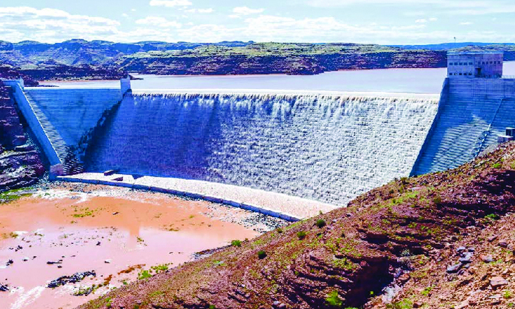
The diversion weir, which is about one kilometre upstream of the falls in Angolan territory, consists of a weir with flap gates for flood control and a diversion channel to the intake of the 1.5-kilometre long pressure tunnel that is partly in Angolan territory.
Except for the headbay, offices, workshops and power lines, the entire complex is underground. The total cavern excavation of the machine and transfer halls and surge chamber required the removal of 135 000m³ of rock, while 260 000m³ of rock were excavated for the tunnels.
The Ruacana hydropower station is the only component of the Kunene River Scheme in Namibian territory. The water in the pressure tunnel flows into a 31.5-metre-deep surge headbay connected to the underground powerhouse complex by four 140-metre-high penstocks. Three turbines with a capacity of 80MW were initially installed, while a fourth turbine was commissioned with a capacity of 92MW in 2012.
Stay informed with The Namibian – your source for credible journalism. Get in-depth reporting and opinions for
only N$85 a month. Invest in journalism, invest in democracy –
Subscribe Now!